Honolulu Department of Emergency Update on the impact of Hurricane Douglas
For a Hurricane:
Sheltering-in-place:
If you live in a house, consider sheltering-in-place if your home meets ALL of these criteria:
- Was built 1995 or retrofitted to withstand hurricane-force winds
- Located outside of a storm surge hazard area.
- You have protected windows AND/OR have access to a safe room, an interior room with no windows or exterior walls and with enough space for all family members, pets, and emergency supplies.
For high-rise condo or apartment (10 stories or higher) dwellers, shelter in place if all of the following conditions are met:
- You have protected windows OR have access to safe room, an interior room with no windows or exterior walls and with enough space for all family members, pets, and emergency supplies.
- You are able to survive without electricity and are capable of climbing up and down stairs to receive emergency information post-storm.
- If your high-rise condominium is within the storm surge hazard area, you may shelter in place if you live on or have access to the 4th floor or above.
If you are not able to meet all of the above conditions, then you need to make plans for evacuation. Please remember that in this moment the storm is the most immediate threat to your saftey. Although the risk of contracting COVID-19 is still prevalent within our community, staying in your unsafe home poses a greater danger to your life. Please consider evacuating to friends or famlily first, and as a last resort, a hurricane evacuation shelter.
Evacuating to friends or family:
If you are unable to shelter-in-place, consider evacuating to the home of a friend or family members that meets the above criteria for houses and condominiums. Take all of your disaster supplies with you.
Evacuating to a hurricane evacuation shelter:
If you do not have any other options, evacuate to the nearest hurricane evacuation shelter. While hurricane evacuation shelters offer some protection from high winds, flying debris, storm surge and flooding, they are intended to be a last resort option for residents and visitors without safer options to use – at their own risk. In almost all cases, the identified hurricane evacuation shelters HAVE NOT been designed or hardened for winds greater than a tropical storm. These shelters are, however, a safer option than remaining in areas prone to flooding, storm surge inundation, or in older homes with wood frames or single wall construction.
Household pets entering shelters must be securely leashed, or in a pet carrier/cage for safety. Owners must provide water and food for their pets, and will be expected to assist in the care of their animals.
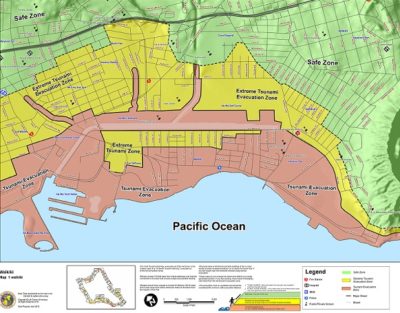
It is important to identify if your home, work, school, place of worship, and other frequented areas are in a tsunami evacuation zone in order to plan accordingly.
Please note that the Oahu Tsunami Evacuation Map illustrates three zones:
For most TSUNAMI WARNINGS, evacuate out of the red zone; for an EXTREME TSUNAMI WARNING, evacuate out of the red AND yellow zones. If you are in a Tsunami Evacuation zone or low-lying coastal area during a strong earthquake, move immediately to higher ground outside of the RED Tsunami Evacuation Zone; a tsunami could reach the shore within minutes.
Insurance: Understanding Your Coverage
Homeowners and renters insurance does not always cover all of the damages and losses that may be incurred by a disaster. Know what is and is not covered by your insurance policy. Read My Insurance Doesn’t Cover What? to understand your coverage.
Map Your Neighborhood
Neighborhoods that are prepared for emergencies and disaster situations save lives, reduce the severity of injuries and trauma and reduce property damage. In addition, contributing as an individual and working together as a team helps develop stronger communities and improve the quality of life in the community.
The Map Your Neighborhood program guides you and your neighbors through simple steps to help enhance your preparedness for an emergency. These steps will help you to quickly and safely take actions that can minimize damage and protect lives. It is designed to improve disaster readiness at the neighborhood level, 15-20 homes or a defined area that you can canvas in 1 hour. It teaches neighbors to rely on each other during the hours or days before fire, medical, police or utility responders arrive.
Map Your Neighborhood was developed by Washington State’s Emergency Management Division. Get started in your neighborhood today!